Trip Journal – Alaska 2004
This trip was really three trips in one. First, I (Paul) had to attend the Big 10 Athletics Business Manager and Ticket Office Managers meeting in Chicago. Then, Ian (my son) and I were going to fly to Seattle to pick up a car to drive the Alaska Highway, Then they were going to meet my father (Don) in Anchorage and explore more of Alaska and take the ferry back to Seattle and fly home...

It was four lane for a while and then became a more scenic two lane highway all the way to Cache Creek. The railroad paralleled the highway the entire way and it was obvious that there are some spectacular vistas from the train through the Fraser River canyon. The interesting thing is that they had tracks on both sides of the river and both sides seemed to be active. Don’t know if they were hedging their bets or just needed more tracks through the canyon.

Trip Journal – Alaska
Sunday 5/23 – Bloomington to Evanston
Ian and I picked up Mike and Mark at Assembly Hall and
headed up to Big 10 Athletics Business Manager and Ticket Office managers
meeting in Evanston. It was a
pretty easy drive, but we talked about the possible weather problems between
Indy and Chicago. As we got
closer to Lafayette, it looked pretty dark to the west, but it looked like we would
get by before it got to us.
Wrong. We were
driving just north of Lafayette and we saw a really strange cloud – kind of a
vertical wall of cloud. And it was
a strange color. Ian and Mark
thought it was just a wall of rain.
I thought it might be something worse than that. As we got closer, it looked even more
ominous. Finally, we drove into it
– it caught up to us – and it was raining so hard, I couldn’t see 3 feet in
front of the van. We slowed down
and I tried to get to the emergency lane, but couldn’t see enough to even find
that. We felt the serrations in
the pavement and got over enough and stopped and Ian pointed out that we should
turn on the flashers. We sat there
for a while. The wind was strong
enough to rock the van. When we finally
could see, there was debris all over the road and a couple of trees had
snapped. We didn’t think it was a
tornado, but it was as close as we want to get in a van….
The rest of the trip was pretty normal, other than the
traffic in Chicago. We did the
skyway route because of all of the warnings about the Borman Expressway. Unfortunately, the Skyway was also
under construction – right at the entrance from I-65 and on the big skyway
bridge. The bridge work looks like
it will be going on for some time (years). So, the bottom line is not to drive to Chicago from Indy for
the next couple of years…..
We got to the hotel and found out that we had a reservation
for only one night (which we had been told, but hoped we could find another
room). That makes the logistics for
us a little more difficult. Oh
well, we’ll deal with it.
We met with all of the Big 10 guys and got our tickets to
the Cubs game and the passes for the “L”
(the only way to travel). We
walked a couple of blocks to the “L” station and took the train to the Howard
station where we had to transfer. We
got to Wrigley field after about 40 minutes. We had forgotten how close to the field you are from the
“L”. You can read the scoreboard
from the “L” platform.
We got out in the mass of people and I made Ian make a
complete circle of Wrigley field so he could get the complete feel for a Cubs game.
This one was sold out and was at
night, so there were quite a few fans in the bars and wandering around. We found our seats (after getting some
food – beer and peanuts for me, pop and hamburger for Ian). The game was great (the Cubs beat the
Cardinals 4-3), but the highlight was when we saw John Cusack walking to the
pressbox to do the 7th inning stretch “Take me out to the Ball
game”. We left after that (in
order to beat the crowds), and were going to stop for an ice cream snack, but
the line was too long.
Monday, 5/24/04 – Evanston - Chicago
The weather was a little cooler today, but I got up and went
wandering to get a paper, a toothbrush (I forgot mine) and a free coffee
(courtesy of the Cubs).
Unfortunately, the free coffee was at Dunkin Donuts, so it was donuts
for breakfast (not as good as Crispy Crème in our opinion).
The Big 10 Athletic Business Managers are a real good group,
but sometimes the topics are pretty hard for me to “get”. I’ve been in Athletics for about 18
months now, and I think I understands most of what is going on, but these meetings
tackle some of the more “arcane” stuff (at least to me). We had a long discussion about ticket
allocations at the Big 10 tournaments (and whether we should have the
tournaments at all…) and discussions about the Bowl games (which IU hasn’t had
to worry about lately). But
everyone seems to have the same issues (costs are outstripping revenues, except
for the very large programs). Even
Penn State is lobbying for relief for tuition expenses.
Ian wandered around during the meetings and found a Wi-fi in
the lobby of the hotel, found a Chinese restaurant for lunch and wandered
around the Northwestern campus.
We met up at about 2:30 and headed for the hotel at
Midway. (I had decided that it was
just too complicated to try to get Ian to the hotel and back for the dinner at
Northwestern. It’s about an hour
drive from Evanston to the airport.)
We caught a limo from the hotel and (for $60), we got delivered to the
hotel about 90 minutes later. The
traffic reminded me why I moved out of Chicago in the first place. (The irony, that will be fully
appreciated by Susie, was that I debated taking the “L” from the hotel in
Evanston to the hotel at Midway.
But it would take at least 60 minutes and I wasn’t sure how close the
Midway hotel was to the “L” station. It turned out to be about 1 block and the fare on the
“L” would have been $1.75 each.)
The hotel (The Carlton Inn) turned out to be in a very
Polish area (at least we think it’s Polish – it’s along Pulaski Avenue…). I went to the local store for beer and
all of the magazines were in Polish and when I got my beer (Zywiec), the
cashier told me what I owed in Polish (at least I think it was Polish). After noticing my puzzled look (I'm very good at that after a couple of trips to Europe), she gave me the total in
English. By the way, did you know
that it’s Marie Sklowdoska Curie (as in Marie Curie High School – directly
across the street).
After a couple of beers, Ian and I wandered down the street
to a neighborhood restaurant that turned out to be pretty good. I got Sagnaki and a greek salad (didn’t
think he’d get much chance for Greek food in Alaska) and Ian got some
pasta. We were both happy with our choices (and we
topped it off with some ice cream).
I took Ian down to the Polish grocery (even all of the items on the
bulletin board were in Polish) and most people in there were speaking something
other than English.
After that, we watched the Pacers lose and turned in. The hotel turned out to be OK, but it
was pretty loud all night (with the airplanes and the traffic).
Tuesday, 5/25/04 – Chicago to Cache Creek, BC
We got up, had a (complimentary) donut and went over to the
airport. Everything worked fine
(other than the flight left 30 minutes before I thought it did). But the flight was routine (other than
a flight attendant who seemed to speak faster than anyone we’ve ever heard when
giving emergency exit instructions…)
At Seattle, we rented the car without too many hassles, and
headed out. The traffic in Seattle
was really heavy (at noon on Tuesday!!).
We saw one wreck on I-5 going the other way where a semi had squeezed a
car into the guard rail (it was tilted up pretty good against the rail). It had traffic backed up quite a ways
southbound.

We stopped at McDonalds for lunch in Everett and then headed
on up I-5. After about 100 miles, we
got off the interstate and drove on some two lane roads to the Canadian border
(not too bad, but a lot of stoplights at the beginning) and caught Canadian
highway 1 (the Trans-Canada highway).
Although it was raining much of the drive, it was very scenic –
following the Fraser River for almost 100 miles.


It was four lane for a while and then became a more scenic two lane highway all the way to Cache Creek. The railroad paralleled the highway the entire way and it was obvious that there are some spectacular vistas from the train through the Fraser River canyon. The interesting thing is that they had tracks on both sides of the river and both sides seemed to be active. Don’t know if they were hedging their bets or just needed more tracks through the canyon.
We left the Fraser River and began to follow the Thompson
River to Cache Creek. This area
was much drier, almost desert-like.
There were some farms, but only where it was irrigated. Evidently, this place grows most of the
ginseng for the North American market (with enough irrigation).
Got to Cache Creek about 6 and checked into our hotel. Ian overheard the couple in front of them
talking to the hotel manager about how to cook bear meat. Evidently they were just back from a
hunting trip where they had shot a black bear. They had saved the skin for a taxidermist, but were hauling
the meat home and were trying to figure out how to prepare it. Somehow, it just didn’t seem
right to Ian and Me.
We went to the local Chinese restaurant. It was excellent. Evidently, there is still quite a
population of Chinese in this area, descendents of the Chinese who worked on
the railroad. (And the restaurant
at the hotel specialized in Greek food – go figure…).
After stuffing ourselves, we wandered the 3 blocks around
town to try to get rid of that too stuffed feeling, and then watched the end of
the hockey game and the end of the basketball game.
Wednesday 5/26/04 – Cache Creek, BC to Dawson Creek, BC
It was a pretty morning. I got up and wandered around town (what little there is of
it – it seems that there are more motels and gas stations than people). Ian got up and we went to breakfast at
the hotel – OK but not wonderful, but after some discussion, we decided we both
thought the waitress was cute (angling for a big tip from the non-savvy
travelers).
Headed out about 8:30 and started the long drive to Dawson
Creek along the Cariboo Highway. We
drove in and out of rain most of the day (the last hour or so was the only
clear part.) The first part was
pretty tame, followed the old mining trails up the Bonaparte River. The highlight was when Ian spotted a
bald eagle in a tree in a field above the river – our first one. Drove into 100 mile (3 stoplights) and
then into Lac La Hache (nice lake but not much else) and Williams Lake (bigger).
Then, the highway caught up with the Fraser River again, and
we drove alongside for quite a few miles to Quesnel. At some points, we were way above the river (a couple of
hundred feet) and there were usually farm fields between us and the river. It reminded me a lot of the drive along
the St Lawrence River last year. Quesnel was a much larger town than any we’d seen since
Seattle. It was big enough that we
found a sub shop (Quizno’s) for lunch and I got a little turned around but
managed to get out of town. It had
a couple of nice parks along the river which we followed for a while longer.
On the way to Prince George, I saw a bear in a field just
off the highway - pretty neat.
Prince George is a very large, very industry-oriented town - lots of
timber and other natural resource businesses. Most of the forest is obviously cut and is re-growing in
this area.
Then we headed up the Hart Highway toward Dawson Creek. This was the section that went over the
Continental Divide and was in the Peace River wilderness (at least for the
first 100 miles or so). It was
spectacular. Just what the
postcards indicate the mountains of British Columbia should look like.
We got a picture of our next bear. Actually, this was the mother bear. There were two bear cubs just out of
the picture. While I tried to get
this picture, one of the cubs moved closer to the car, and the mother started
moving over to make sure things were OK.
At that point, we left.


The rest of the drive to Dawson Creek was OK, but not as
scenic. Although there were lots
of moose crossing warnings, I still did not see my moose. The last 50 miles into Dawson City was
pretty flat (and agricultural). But
we did make it to Dawson Creek, and made the required photo stop at mile 0, and
had pizza for dinner.


Thursday, 5/27/04 – Dawson Creek, BC to Liard Hot Springs
This morning started off sunny and beautiful. The sun seems to come up at about 4 or
4:30. I got up about 6 and
wandered about a little (did a little e-mail – the hotel had wireless internet
connections for a nominal fee).
And he finally got Ian up about 7.
We wandered down to the complimentary breakfast (basically bagels and
coffee, milk or juice) and started on our way to Liard Hot Springs. This was going to be one of the longer
drives, about 500 miles.
The beginning of the drive was pretty much like the midwest
– the area was mostly farming and was flat – kind of reminded me of Saskatchewan
or eastern Alberta. But we did
drop down to cross a couple of rivers which was pretty exciting. It soon got pretty overcast and started
raining again. The traffic to Fort
St. John was the heaviest we’d seen since Seattle. After Fort St. John though, it was very sparse. The road was very wide and pretty straight almost the entire
first 300 miles. It was really not
too exciting, other than the continued warnings of moose crossings and elk
crossings. Ian did see an elk and
a coyote (or wild canine of some sort) around Pink Mountain. Other than that, up to Fort Nelson was
pretty boring. (At one point in
the guidebook, they talked about one road reconstruction project that took out
100+ curves in a 10 mile stretch, and it looked like they had managed to make
the road completely straight for 10 miles (not a bend in sight).
As we drove along, we contemplated some of the rather
strange things about the road. One
was that they seemed to have decided to keep 30 feet on each side of the road
clear of any vegetation. This is
kind of nice if you are on the lookout for wildlife, but it didn’t give it a
real wilderness feel. Also, almost
the entire way was either tree farms or natural gas wells. It was a little disconcerting to see
how much of the forest has been cut that far north, and the gas wells were
everywhere. Last, but not least,
there were these things along the side of the road – three sticks tied together
like a pyramid. They were
everywhere. I figured they must be
some sort of surveying tool, but why would they use sticks??
We finally got to Fort Nelson. For all of the build-up, it is a tiny town (population 4000). We got gas, went to local deli for
sandwiches and ended up stopping at the visitor center to use the bathroom.
Then it got interesting. The first part of the drive was pretty normal (other than
the buffalo ranch outside Fort Nelson).
But soon we were getting up into the mountains and crossing the highest
point on the Alaska Highway at Stone Mountain Provincial Park and Summit Pass
(Summit Lake was still frozen).
This section was stunning.


(It was also raining at the higher elevations). We saw stone sheep (and took lots of pictures). Then it was on to Muncho Lake where they basically blasted a ledge for the highway, right next to the lake (the road appeared to be on fill). One of the interesting notes we saw was that even though Liard River runs from Fort Nelson to Liard Hot Springs, the road engineers decided it would be easier to put the road up through Summit Pass and next to Muncho Lake, rather than try to put a road through the Liard River canyon – must be quite a canyon).
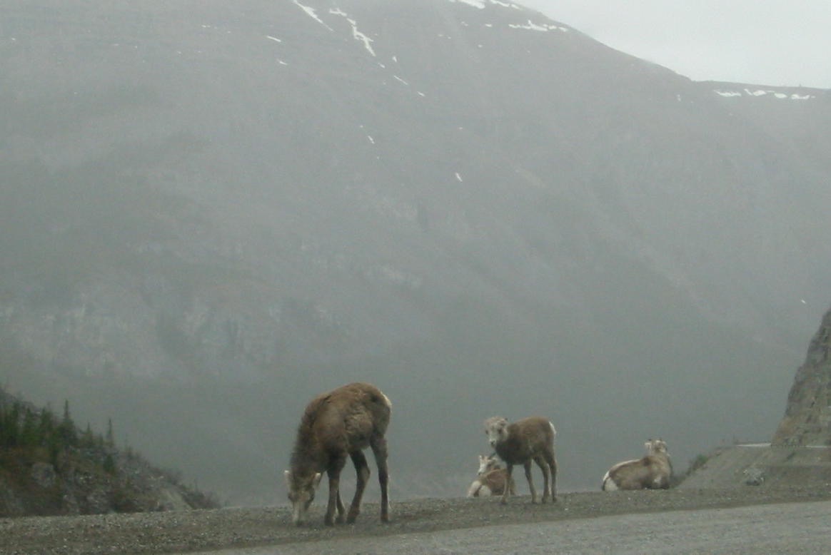

(It was also raining at the higher elevations). We saw stone sheep (and took lots of pictures). Then it was on to Muncho Lake where they basically blasted a ledge for the highway, right next to the lake (the road appeared to be on fill). One of the interesting notes we saw was that even though Liard River runs from Fort Nelson to Liard Hot Springs, the road engineers decided it would be easier to put the road up through Summit Pass and next to Muncho Lake, rather than try to put a road through the Liard River canyon – must be quite a canyon).
The lake was gorgeous (we drove along one side of it for
about 5 miles). The entire drive
was really spectacular. And
isolated. There were very few
places to stop. (It appears that we
need to start getting used to that.)


The one downer on the drive was that, as we rounded a curve as
we were going through the mountains and saw a bunch of smoke up ahead. It seemed like wood smoke, but there
were little reflectors set up to warn us of a problem up ahead. As we got there, we noticed the outside
guard rail flattened and there was a vehicle (I thought it was a truck, Ian
wasn’t so sure) upside down, on fire, at the bottom the ravine. It wasn’t clear how long ago the
accident had happened. We asked a
truck driver if it had been reported and he said it had. No idea what happened to the driver.
We drove on (more carefully- we managed to avoid the wild horses
on the road) and got to Liard Hot Springs, checked into our hotel and went to
check out the hot springs. They
are very nice (I will probably try them again tomorrow morning). And the rumor is that there are moose
hanging around – I will definitely check that out.


We had dinner at the hotel and went to our room to read and
work on the computer. Our room
didn’t have a TV or telephone, so it was kind of like camping…. The only thing wrong with the Liard Hot
Springs Lodge is that they didn’t sell beer and the nearest place to get it was
125 miles in either direction. Oh
well, better planning next time…
I went out later to look for moose, but didn’t find
any. Instead he found buffalo on
the road. There was a small group
(12 or so) heading toward the lodge in the middle of the road. There was a semi blocked and even when
he honked they wouldn’t budge.
After about two minutes, they let me through and I made it back to the
hotel (and shelter).
We turned in pretty early….
Friday, 5/28 – Liard Hot Springs to Whitehorse, YT
I got up early to try the hot springs again (and look for
moose). The hot springs were nice
(I had the upper pool all to myself).
But, after about 10 minutes, he heard something that sounded like
noisemakers. I remembered a sign
at the entrance notifying all visitors that the park service was trying to
“re-educate” some of the bears by using noises and to not be startled – they
were guaranteed to not hurt the bears.
Well, when I heard that, I thought, hmm, maybe being alone in this pool
isn’t such a good idea. Then I
heard some other noisemakers in a different direction and decided to retreat. They may have been going off at random
times, but no need to find out first-hand.
I made it back to the first pool unscathed. I did pass the two woodchucks I had
seen on the previous trips, and tried to get a picture (again), but they were
too fast. After that adventure, I got Ian up, we ate breakfast, and hit the road. I was a little concerned because I heard this stretch of
road was pretty rough with a lot of gravel (the sign at the Hot Springs park
indicated that it was mostly gravel).
After getting by the buffalo, Ian and I both found the drive to be
easy. The only gravel was at a
couple of construction areas.
For this day, the only wildlife spotted were three bears and
a fox. We stopped for lunch at the
Continental Divide restaurant (very unmemorable). This continental divide is between the Pacific and Artic
oceans. Evidently, everything for
now on is on the Pacific drainage.
There was one signpost that noted that the Pacific drainage could
support many more people/animals due almost solely to the salmon migration. The other thing we noticed is that it
is very dry in this area – a lot of sand and rocks and the trees are not as
dense.
We got to Whitehorse, a very large city by the standards of
the region. After we found our
hotel, I went for a walk around town while Ian read. We figured out where the Laundromat was (for tomorrow) and I
found an interesting restaurant.
The restaurant advertised itself as the best in Whitehorse
for 5 years running. It was good,
but very crowded, so the service was pretty slow. (I prepared myself for this by ordering a pitcher of beer
instead of one at a time…..). But
the best part of the meal was that they sat you at large tables that you shared
with others. We struck up a
conversation with the guy at our table finishing up. He ran a travel business in Skagway for the summer months,
but then went back home to Eau Claire, Wisconsin. He had a lot of tales to tell about hunting, other
restaurants, and the region in general.
After he left, a couple was seated next to us. It turned out they were a retired
couple from Michigan, on their second trip to Alaska. The lady was an amateur geologist (an ex-school teacher who
taught earth sciences), so they planned their trips around rock hunting
expeditions. They were even
planning to make it all the way to Prudhoe Bay this time. It was fun talking to them. After a huge dessert (definitely worth
it), it was off to bed.
Saturday, 5/29/04 – Whitehorse, YT to Beaver Creek, YT
Got up in the morning and headed out to do laundry. The Laundromat was next to a McDonalds,
so that solved the breakfast issue.
I also found a post office where I could mail the postcards I had for
Susie. It turned out they required
Canadian stamps.
The drive today was a short one, only 300 miles. So, the late start wasn’t too much of a
concern. This section of road
turned out to be quite a bit rougher than any of the other sections thus far,
especially after Haines Junction.
There were a few construction areas where the road was reduced to gravel
(probably 15 miles total). But
after Kluane lake (which was beautiful – the largest lake in the Yukon), the
road was very uneven – the guidebook mentioned frost heaves. Anyway, it was quite a roller coaster
ride.
The scenery was amazing, especially the mountains around
Haines Junction and Kluane Lake. We
stopped at the sheep mountain visitor center, and since we were the only ones
there, the ranger showed us where the sheep were high up in the mountain (with
binoculars and telescopes.) We didn’t
stop for lunch, but stopped for a snack about 2 hours from our destination at
Beaver Creek (just inside the Canadian border).
While we were driving around Kluane Lake, we thought it was
nice that we could take these scenic roads instead of the main roads. Then we realized that this was the main
road. It is the only road that
goes through this area. It’s the
only road that connects these towns/countries. So, when they need to do roadwork, they don’t really have
any detour alternatives. Kind of
changes the planning significantly…..
Today we saw a mother bear and her two cubs (but we don’t
think the picture will turn out).
The mother was brown, but the two cubs were black, so we assumed they
were black bears. And I thought he
saw an eagle (a large bird with a white head) in flight over the highway.
Got to the hotel (Westmark Beaver Creek) and found out that we
have another one without a TV or phone in the room. Evidently they have a lounge with a TV (and beer), but it didn’t
open until 6. We can probably wait
until then.
I took the tour of the town – 3 hotels/restaurants/gas
stations, 1 visitor center 2 churches (but they only have services every other
week) and about 12 houses. Didn’t
take too long.
After that, it was wait around (i.e. reading and/or napping)
until 6 and then over to the lounge to watch the hockey game, drink beer
(cranberry wheat??) and have some dinner.
Notes on driving the Alaska Highway. The road is quite easy to drive in most
places. From Dawson Creek to
Whitehorse, the highway is a wide, relatively straight two-lane road with lots
of passing areas. The only
exceptions were in the mountains (around
Stone Mountain and Muncho Lake) and in the couple of construction
areas. After Whitehorse, there was
more construction and the road was narrower. Between Haines Junction and Tok, the road was much rougher,
there were fewer passing areas, and more construction. Between Tok and Delta Junction (and
Fairbanks), the road is wider and smoother and there wasn’t much construction.
But it’s important to note, that we saw relatively few cars,
once away from the 5 or 6 large towns.
There were times where we would go 15 minutes without seeing another
car. In the entire drive to
Fairbanks (1600 miles), we probably passed (overtook) 50 vehicles (40 of which
were RV’s or semi’s) and were passed by maybe 20 cars. But we were driving this before the
high season.
Sunday, 5/30/04 – Whitehorse, YT to Anchorage, AK
We got up, ate breakfast in the hotel dining room, and hit
the road. Canadian Customs was
only a couple of miles away, but it turned out US customs were about 15 miles
further, in kind of a no-man’s zone.
We saw little in between, other than the welcome to Alaska sign. We had to stop to get the requisite
picture. And they had a very
interesting signboard about permafrost and how difficult it was to build roads
in the area. It prepared us for
the roads in Alaska.


At US Customs, the lady gave us a hard time about not having
passports (we thought driver’s licenses were enough, but she said anyone can
get a driver’s license…). Anyway,
she let us in.
We stopped at the first gas station because the gas prices
are less in the US. It was
cheaper, but a little rustic. When
I asked to use the bathroom, the guy said he was working on it and told me to
use the bushes. Welcome to Alaska.
The first part of the drive was kind of dull. The scenery was not anything
spectacular, and the road had a fair amount of frost heave, and we saw no
wildlife. But the drive was easy,
virtually no traffic.
We stopped for lunch in some diner at the intersection with
the Richardson highway. The food
was not anything special, but the lady did tell us that there was a visitor
center for the Wrangell-St. Elias National Park up the Richardson highway about
10 miles, so we backtracked and visited the visitor center. I bought a National Park Passport and a
new CD (we were tired to listening to the same CD’s). You really couldn’t go into the park in this area. It looked to be quite a wilderness, almost completely undeveloped.
We headed on down the Richardson Highway toward
Anchorage. At some point, we crossed
over the Alaskan Pipeline (didn’t see it). The road was nice and we started getting into some really
spectacular scenery. At one point,
Ian was looking for a place to pull over for a picture and I spotted a moose on
the other side of the road and yelled to stop. We got the car stopped in time to get a picture of it as it
crossed the road. (It was very
well behaved, stopping and looking both ways before crossing.) Finally, I got my moose. It was the only wildlife we saw the
entire day.


But, the scenery kept getting more and more
spectacular. It was better than
the Alps. We even got close to a
Glacier on the drive. There was
some roadwork, but it was not a problem as we admired the scenery.


As we got closer to Anchorage, the area got more civilized. We went through Palmer, which evidently
(according to the guidebooks) was settled as part of a government plan to
settle Alaska in the 30’s. It is
the agricultural area of the state, which is still quite a feat (the growing
season is still quite short).
The drive into Anchorage from Palmer was a lot longer than
expected, about 40 miles of divided highway past the turnoff to Fairbanks. Once in Anchorage (a very large city –
It has at least 40% of all of Alaska’s population), we found our hotel and
checked in. I noticed that there
was a brew pub directly across the street, so it was there for dinner. I sampled all of the beers (none
outstanding, but all drinkable) and Ian ordered some Alaskan fish, and it was
good, but a little too fancy for him (there was even a little verticality
involved). It was evidently rated
as one of the better restaurants in Anchorage.
We wandered around looking for souvenirs and then retired to
wait to pick up Dad at the airport.
We got there a little early (admiring all of the other airports in
Anchorage – 2 small plane airports (one the busiest in the US) and one float
plane airport. The plane was a
little late, but we met up and headed back into town. There was a rainbow over the city at that time. We considered that a good omen. After getting Dad checked in, we all
turned in (it was 2AM Indiana time).
Monday, 6/1/04 – Anchorage, AK to Seward, AK
We got up, Dad and I had breakfast in the hotel and then
went out to the Earthquake park, commemorating the 1964 earthquake which hit
southern Alaska. It was
interesting (hard to believe that it was that destructive – it actually
destroyed two seaports and most of Anchorage’s seaport at the time). The mosquitoes were finally appearing
in force.
After we got Ian up, we headed for the Kenai peninsula. I wanted to see a glacier up close and
there was one down toward Seward. We
started the drive in the rain, and the traffic was pretty heavy (we had to
continue to remind ourselves that this was Memorial Day).
We got to the glacier and caught up with a ranger trip and
had a great time walked to the foot of the Exit Glacier.

Did you know that moose droppings are almost completely sawdust??? Evidently, their diet is almost exclusively willow trees and after digested, the droppings are almost entirely wood (makes good fire starters).

Did you know that moose droppings are almost completely sawdust??? Evidently, their diet is almost exclusively willow trees and after digested, the droppings are almost entirely wood (makes good fire starters).
We drove back, not as much rain, but a lot of traffic. It was basically one long stream of
traffic back to Anchorage. We got
back to Anchorage went to the Alaska Zoo.
It was a nice small zoo, and mainly had animals that could survive in
Alaska (bears, moose, caribou, owls, eagles, etc.) Then we got back to the hotel and had happy hour while we
watched bad TV. Then we had to
find a place to eat. It ended up
decided by a coin flip and we ended up at a salmon bake. The food was just OK, but Dad’s dessert was
excellent. We wandered back via
the souvenir shops and got back about 8 and turned in.
Tuesday, 6/2 – Anchorage, AK to Fairbanks, AK
We got up (even Ian) and had breakfast at the hotel. Then it was on the road. Destination - today, Fairbanks via Denali National Park. Again, the traffic was heavy while we
worked our way out of Anchorage and the suburbs. There seemed to be a lot of tour busses on the way to
Denali. But after a while, traffic
thinned out a little.
We did go through Wasilla, just outside of Palmer, north of
Anchorage. Evidently, it is
becoming a suburb of Anchorage even though it is 50 miles away. The property is relatively inexpensive
and it’s not that bad of a commute (by Alaska standards). It is the fastest growing community in
Alaska and about the 5th largest city in Alaska (population 6,000). But its claim to fame is that it is the
headquarters of the Iditarod race.
They have a ceremonial start in Anchorage (I heard that they truck snow
into downtown for the start), but then the race actually starts in
Wasilla. They have the
headquarters in Wasilla and a lot of the “mushers” have their homes open for
tours. Quite an industry, it
appears.
We also passed through Willow (population 500) which was
supposed to be the new state capital of Alaska in a more central location (according
to some), but the move was never funded by the State Legislature.
We did see a caribou on the side of the road by a gift shop.
We wondered if it was a tame
caribou….. Other than that, there
was not any wildlife or much scenery until we got close to Denali National Park,
since it was cloudy. I really
wanted to see Denali, but there was not much hope with the cloud layer.
We finally made it to the National Park (it was a lot longer
drive than we thought). The park
is not set up for a lot of visitors (it is in Alaska, which is a long drive for
most people). The parking lots are
small (although the RV lot is as big as the car lot and there is a lot of space
for bus parking). They encourage
people to take buses through the park.
They do allow cars to drive the first 12 miles or so, and we decided to
do that hoping to see some wildlife, but no luck. We stopped at the turnaround point and Ian and I did spot
some mountain goats high up on the mountain (with the help of Dad’s
binoculars), but Dad couldn’t find them (you had to know what you were looking
at).
On the way back, however, there was a moose grazing along the side of the road, collecting quite a tourist following. We got a pretty good picture of him (her). We had lunch at the little camp store (sat outside it was so warm). Then we started the drive on to Fairbanks.
On the way back, however, there was a moose grazing along the side of the road, collecting quite a tourist following. We got a pretty good picture of him (her). We had lunch at the little camp store (sat outside it was so warm). Then we started the drive on to Fairbanks.

On the way, we passed through the little town of Nenana, a
small town north of Denali which is the center of the barge traffic for supply
routes to the northern community along the many rivers. But its claim to fame is that it holds
the annual ice classic where all Alaskans guess (and bet) on when the break-up
of the Nenana river will occur.
They build a tripod on the ice and connect it to a stop watch on shore
via cable, and when the tripod starts to move, it stops the clock. This does seem to be a big deal – the
winner got over $300,000 last year.
Again, it was a lot longer than we expected. And it was not very scenic (no fauna),
and the road was relatively flat going into Fairbanks.
Finally got there, checked in to the hotel, and Dad and I
went out for beer. I suggested we
forget the local specialities and go for pizza and beer tonight. No argument from the other guys until
he got the local pizzeria menu and suggested the Alaskan Halibut pizza. No one else was going to go there…. We got a meat lovers pizza (Dad and I also
had salad to go with our beer).
Watched the Pacers lose and other bad TV (Ian found a bad movie on the
sci-fi channel).
One thing to note is that it was very hot that night,
probably in the mid-80’s. And
Alaskans aren’t too much into air conditioning, so we all suffered a little
bit. And it seemed to stay light
until 11 and got light again about 2:30.
Before we turned in, Dad and I did walk over to the bird
sanctuary (the hotel is next to the Creamer Field Migratory Waterfowl Refuge). First we stopped off at the little
cabin and airplane on display at the hotel (the Wedgewood resort). There was an old guy giving little
explanations of the way the miners and trappers lived. He was very interesting. He said he left Long Island when he
graduated in 1952 for Alaska (driving the Alaska Highway when it was a real
adventure and sleeping in his sleeping bag for the first four weeks until he
got a job in one of the mining camps).
Eventually, he took up surveying and stayed in Fairbanks his entire
life. His Indiana connection was
that his daughter and her husband both got their doctorates at Purdue, so he
had been to visit them (babysitting duty).


After than, we tried the waterfowl refuge, but the
mosquitoes sent us back to the hotel room pretty quickly. We are beginning to believe the bugs
are really as bad as advertised.
Wednesday, 6/3/04 – Fairbanks to Dawson City, YT
It was pleasantly cool in the morning, and Dad and I decided
to try the waterfowl refuge again (maybe the mosquitoes weren’t out yet). It started out OK, but soon we noticed
the mosquitoes again. We came
across two ladies coming the other way who were completely draped in mosquito
netting. One of them had at least
30 mosquitoes buzzing around her head.
I started thinking that maybe my idea of shorts and a T-shirt wasn’t
such a good idea. The ladies
looked at Dad and me as strangely as Dad and I looked at them. Needless to say, the rest of the walk
wasn’t much fun. I don’t think I’ll
be able to give blood for another month or so, until it gets replenished.
We got everything together and headed to downtown Fairbanks
for breakfast at the Captain Bartlett Inn. This was one of those hotels mentioned as a truly Alaskan
hotel. It was kind of old and worn, but the food was good. They
had quite a few stuffed animals (bears, wolves, etc.) amid all of the log cabin
décor. It was definitely unique.
Then we headed out of town. We went by (through – it’s sometimes hard to tell) North
Pole, Alaska. This is a town I
didn’t think existed a couple of years ago – long story for another time. Anyway, the other thing of note that we
drove by was Eielson Air Force Base.
There are a lot of military bases in Alaska, so the only reason to
mention this one is that the runway is right next to the highway and we saw
three fighter jets (F-18’s??) take off in rapid succession. Pretty neat.
The rest of the drive to Delta Junction was nothing special,
other than it started to rain.
Delta Junction is the official end of the Alaska Highway (where it meets
the Richardson Highway which goes on to Fairbanks). We had to get out of the car to take the requisite “End of
the Alaska Highway” pictures, and, boy, did we notice the difference in the
temperature. It had to be in the
mid-40’s with a nice stiff breeze.
We didn’t stay out of the car any longer than we had to.


Right after Delta Junction, we passed the Alaska Pipeline
(tried to get pictures, but it was raining pretty hard). The rest of the drive to Tok was pretty
routine. When we got close to Tok,
we could see some quite high, snow covered mountains through the clouds. Neither Ian nor I remembered seeing
them on our way through earlier.
(Maybe it was cloudy then, too…..)
We got gas and ate in Tok, and then moved on to the Taylor
Highway and the Top of the World road to Dawson City. This road was reputed to be one of the best drives in Alaska,
and probably would have been if we hadn’t been in the clouds much of the
time. We got to Chicken, Alaska
(population 12), and I bought the required souvenir T-Shirt. (One of the really good stories was
that the original miners wanted to name the town Ptarmigan after the bird they
had been catching and eating (now the state bird), but no one could figure out how
to spell it, so they compromised on Chicken…..)
Then we headed through the 40 miles of gravel road to the
Canadian border. We passed a
couple of active-looking gold mines (both small scale) on the way.
As we got close to the border, we got higher up. It wasn’t raining as much, but it was
still very cloudy. But you could
see that it would be spectacular on a clear day. The border crossing was one of the most desolate spots
imaginable. This has to be the
least active border crossing between the US and Canada. The road on the Canada side was
supposed to be paved, but it seemed like at least 30% of it was under
construction (gravel).
But we made it to Dawson City and took the ferry across the
Yukon River into town. This is
kind of the ultimate Alaska/Yukon historical town – located at the confluence
of the Yukon and Klondike Rivers.
It was the center of the gold rush in the late 1890’s.


We found our hotel (nice), I scouted out the town and bought
some gifts, we had dinner at the hotel (nice) and Dad and I went over to
Diamond Tooth Gertie’s to try our luck at the casino. Dad hit the jackpot on the slots and we left about $65 to
the good – quite unusual for Dad.
Thursday, 6/4 – Dawson City to Skagway
The weather had improved somewhat in the morning – it was
cloudy but warmer. We had
breakfast at the hotel restaurant (good), got some more gas, and headed down
the road to Skagway – the last leg of the road trip. The road from Dawson City to Whitehorse was a lot longer
than anyone anticipated. There
were quite a few sections under construction, but the traffic was light, so it
was not that much of a problem.
The road had quite a few historical sites, basically explaining all of
the mining in the area (not only gold, but silver as well). One item of note is that as we left
Dawson City, we passed mile after mile of very large piles of rocks. Evidently, they were tailings left over
from the gold mining in the area.
They definitely left no stone unturned in their search for gold along
the Yukon and Klondike Rivers.


As we drove along, Dad and I saw a bear cross the road up ahead
of us. (too far away for a picture)
We all saw a couple of elk near the lunchtime restaurant. We stopped at a restaurant known for
its huge cinnamon rolls and hamburgers.
It looked deserted, but the two vans in the parking lot held about 20
people. So, service was slow, and
the food was not all that good.
By the time we got to Whitehorse, the weather had turned
great again, sunny and warm. At Whitehorse
we looked for a car wash with no luck, so we moved on toward Skagway. That drive was pretty routine until
Carcross. There, we passed through
the world’s smallest desert (kind of weird seeing sand dunes surrounded by snow
covered mountains). Then we got
into the Coastal mountain scenery and it was really beautiful again – lots of
lakes and ponds surrounded by mountains.
We were allowed back into the US again and, other than the brakes not
liking the 3,000 foot descent into Skagway, got to town and found our hotel
without any problems.


I again scouted out the town and found that the ferry terminal
will not open until 3 hours before the ferry arrives on Saturday, so we has to
sit tight and assume the reservation is still good.
We ate at a local bar, the Red Onion, which is also a
converted bordello (with a bordello museum upstairs). It was loud and the food wasn’t that good. Probably won’t go back there tomorrow. We walked around town a little and
looked for souvenirs and then turned in.
Friday 6/5 – Skagway
Everyone was on their own for breakfast this morning. Ian really wanted to sleep in and Dad
was still on Indiana time. So, Dad
got up and found a place for breakfast.
I wandered through town looking for a car wash and a laundromat – I
managed to find both within a couple of blocks of the hotel.
I got some pastries and milk for Ian and I for breakfast and
then went down to the car wash with Dad and we tried to get most of the dirt
off the car. Then off to the
Laundromat. During that, we did a
little scouting in the shops.
Dad and I signed up for a historical tour of Skagway at 11. It was pretty good, talking about the
history and characters involved in the beginnings of Skagway. Then we had lunch at a little diner
(OK) and turned in for naps. Later
in the afternoon, we wandered around the stores, Dad and I had happy hour in Dad’s
room, and we had dinner at a nearby restaurant. After dinner, we went back out to the shops for Ian to buy
the statue he was admiring, but everything, other than a couple of bars was
shut up (at 8PM on Friday night).
I’m sure it had something to do with the fact that there were no cruise
ships docked at the time…..
Anyway, it was nice to spend an entire day without driving
the car.
Saturday, 6/6 – Skagway to Juneau (ferry)
I got up at 4:30 to go to the ferry office to pick up the
tickets. We didn’t have to board
until 7:30, but I wanted to be sure we had tickets. I went back and got Ian and Dad up and we went to a local
diner for breakfast. It was good,
and very busy. It turned out that
the ferry had just arrived and a large group of girl scouts descended on the
restaurant, along with the people who were planning to catch the ferry.
The ferry was an interesting experience. It is definitely more of a car ferry
than a person ferry. They started
loading cars at 7:30 and finished about 10:00. The ferry was supposed to leave at 8:45. It was fascinating to watch them try to
maneuver all of the vehicles in.
It was absolutely jammed.
Luckily we were one of the first to board so we didn’t have to watch how
close they got the cars.


We didn’t get to our cabin until about 10:00. The ferry was late getting in and they
hadn’t been able to clean all of the cabins. We got a 4 berth – no sitting room cabin. It is very tight. I think we’ll make it work for 3 of us,
but it would be hard for 4. There
is a lot of other space on board, especially if it’s nice (a lot of deck space
up top.)


So, the ferry ride is everything people talk about. Even though it was cloudy and rainy
leaving Skagway, it was still spectacular. The first stop was at Haines, only 14 miles from Skagway,
but there are no roads connecting the two. There are roads to both places, and they form a 350 mile
loop if you ferry your vehicle between the two. A lot of people did that, so it was pretty interesting to
see them try to get the vehicles out and the new ones on. We were there for quite a while. (We didn’t get off the boat because the
town was about 4 miles away.)
There was a naturalist on board talking about the mountains,
glaciers and wildlife. We saw a
whale, some dolphins, and a lot of mountains.


The next stop was Juneau, at about 5PM. Juneau is just surrounded by beautiful
mountains. I tried to get some
pictures, but it’s doubtful that any will capture the beauty of the place. The ferry wasn’t going to leave until
9:30, so I decided we had to see the city. Unfortunately, the ferry terminal is about 15 miles from the
center of town, so it was a $30 cab ride both ways. But, we got downtown (the cab driver was great – a Butler
graduate), hit some of the shops, had dinner at the “Original” Red Dog
Saloon. It was interesting; the
food was good, there was sawdust on the floor and they had a singer who was
actually very good (it appeared that he was more for the cruise line
customers). (The cruise liners
stopped right at downtown, so they were all over the shops and restaurants.)
We also saw a lot of native people (from First Nation) in
costume walking down the streets because there was a big conference that
night. We didn’t stay for it.
On the drive back, we saw a bald eagle sitting on a stump in
a field near the road. It was much
larger than we had thought…. We got
back to the boat and turned in.
Sunday, 6/7 -
Petersburg to Ketchikan (ferry)
We stopped at Petersburg, AK at about 4 in the morning, but
no one got off to check it out because it was too early and it was
raining. (I heard later from the
naturalist that you should at least get off the boat and step on dry land so
you can do a “Technical” – technically, you have been to the place.)
The next stop was Wrangell. Dad and I got off to check it out, but could find nothing
open (it was Sunday morning). But
it was good to get off the boat.
One thing we did notice is that a lot of people were getting off to walk
their dogs – One yard had a sign in it – “This is not a potty for your pampered
pooches”. We’re not sure exactly
how this dog thing works, seeing as how we will be spending 36 hours on the ship without
a stop between Ketchikan and Bellingham.
The next stop was Ketchikan. On the way, we spotted a killer whale (there was all sorts
of excitement in the water, then we saw the blow hole exhale and the tail going
down. Looks like he/she was having
lunch. We also saw a number of
dolphins, and some bald eagles.
We got off the boat in Ketchikan and walked toward the center
of town. Again, it was about 3
miles from the ferry dock. We made
it about a mile and a half, but on the way, we saw at least 12 bald eagles in
the trees above the road. It was
pretty amazing when there were 3 or 4 in the same tree. Again, I tried to get some pictures,
but I’ll be lucky if they turn out.
We got back to the ship, and had dinner there. The current verdict is that the food is
OK – better than train food, and better than a lot of the food we had in Canada
and Alaska. But, certainly not up
to cruise ship standards.
We all finished our books, and began to trade off. Tomorrow is all day on the boat. It should be interesting.
Monday, 6/8 – Ketchikan to ??? – ferry
This was the all day ferry leg. The scenery was still quite nice, but after a while,
everyone was pretty used to it and took it for granted. No one saw much in the way of fauna,
although Dad saw a school of fish being visited (attacked) by a flock of birds
– the water was just boiling.
We had a couple of open water crossings which were
interesting. The longest was an
hour and the sea was pretty calm.
But the boat did some basic rocking. It kind of felt like a roller coaster…. No one seemed to be too bothered by it,
but everyone could imagine what it might be like if the seas were higher (and
the crossing longer).
It was a very slow day, a day to read books, work on puzzles
or whatever. One note. My opinion is that if you like taking
Amtrak, you’ll love the ferry.
They are very similar experiences, but there’s a lot more room on the
ferry to roam around. Most people
were doing laps around the boat, along with hanging out in the various
lounges. The only real drawback on
this particular ferry is that the food was served cafeteria style and you
couldn’t take your meal out of the dining room. Which meant you couldn’t have beer or wine with your
meal…. It’s not clear if the other
boats are set up that way.
Anyway, after trying out the lounge, everyone retired to
read their new books.
Tuesday, 6/9 – Bellingham to Seattle
The excitement of the day was docking at Bellingham. Dad was worried about getting up on
time, but he needn’t have worried about that. The ship’s crew seemed more anxious to get us off that we
were to get home. There were many
announcements and even knocking on all doors to be sure everyone was up. While watching the docking process, I
saw a bald eagle fly over the ship.
The only excitement was when I couldn’t find my camera while
packing. I went to the Purser and
asked for help. She made an
announcement over the PA and within 30 seconds someone came down to the desk
with the camera. It’s kind of
indication of the type of people on the ferry – a good group of adventurers…..
After docking, everyone got to drive their vehicles out onto
dry land again. (I did notice that
the Amtrak station was right next to the ferry dock (within 100 yards) – seems
like you could go all the way to Alaska without flying if you had the
time.)
The drive to Seattle was uneventful, although the weather
was gorgeous again, and the scenery was even prettier than Ian and I
remembered. We found our hotel and
checked in (very early – 10:30).
And then I (who was the only one who has ever been to Seattle) led them
on a walking tour.
First, we went to Pike Street Market. (I liked it, but Dad was bothered by
the crowds.) Then to Pioneer
Square, where we checked out the Underground Seattle tour. We had lunch at the “oldest restaurant
in Seattle”. It was OK (they ran
out of ham and lemonade????). Then
we took the tour. It was
interesting how Seattle solved their water problem by basically building the
roads and sidewalks 10 feet above the tide plain, so in most buildings, you are
really entering on the second floor – pretty ingenious. Anyway, it reminded all of us of the “sewer
tour” in Paris, which we had done together about 3 years ago.
Then we walked over to the Klondike Gold Rush museum to
close the loop on that part of the trip.
It was actually much better than the museum in Skagway. Then we walked back to the hotel
(about 2 miles). We all decided we
had had enough touristing and read, rested, ate at the hotel and watched TV
(basketball and bad movies and bad do-it-yourself shows….) I kind of wanted to get everyone out to
a place where we could see Mt. Ranier (it looked to be clear enough), but that
will have to wait for another time.
Wednesday, 6/10 – Seattle to Indy
Ian and I dropped Dad off at the Delta terminal and turned
in the rental car. We went to the
airport early in the hopes that they had wi-fi connections. (The rent a car people didn’t blink an
eye when we turned in the car with over 4000 new miles on it. By the way, the Ford Escape worked very
well during this trip. And the
seats must have been OK since no one complained of back pain after all of that
seat time.)
It turns out the airport does have wi-fi, for a fee -
$7/day. We gladly paid it in order
to try to get caught up.
The flight to Indy was fine, other than the fact that ATA
ran out of meals on the flight.
They have changed their procedures and now sell meals (for $5) on their
longer flights. Unfortunately,
they judged the demand incorrectly and sold out before they got half way
through the airplane.
The flight to Indy was delayed about an hour for some reason
(we got a lot of different explanations – weather, equipment problems, air
traffic control). Anyway, we got
home and started getting back into the real world…